|
What settings are persistent?
|
|
The favorites list, the follow vessel, and any preferences from the Settings page are persistent.
|
|
How do I replay past events?
|
|
You may enter the Data Replay mode by clicking on the Past button at the top of the Home screen. From the History page you may select
a 90 minute window of data between any two river miles. Please note that the narrower the range of data the faster the playback will work.
If the Historical data server is experiencing heavy loads the request may time-out and you will get a message asking you to try later. Peak use hours
that will cause this message are between 6 and 9 in the morning and at the top of the hour.
Once your data file loads, you will be taken to the Map page. At the top of the Map page you will see 4 buttons. The Data button will take you back to the
data selection screen and the Measure button works just as it does in live data mode. Clicking the Next button will advance the replay in 5 minute intervals
and change the text in the button to the time stamp of the current view. The Rewind button will reset the map view to the start of the data set.
To exit the Replay mode, simply return to the Home screen by clicking the Data button and then Home.
|
|
Can I use larger Icons to view the traffic?
|
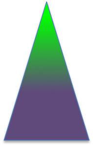
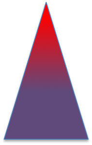
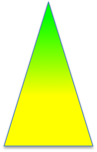
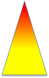
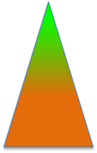
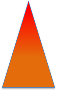
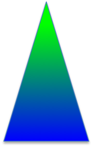
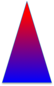
To switch the map display to Icon mode, go to the Settings page and tap the Use Icons switch. In this mode you will not be able to use the Anchorage
Auto Gap feature but all other features will work as expected. All vessels will now be the same size and represented as colored triangles. Vessels that are
moving have a green tip and those that are at anchor have a red tip. The base of the triangle is color coded by ship type:
| Vessel Type |
Icon |
| Tugs |
|
| Tows |
|
| Tows over 200 ft. |


|
| Passenger |
|
| Cargo |
|
| Tankers |

|
| Navigation Aids (VATON) |

|
| Miscellaneous |

|
| Dredges |

|
| Known tugs |


|
|
|
Where does the data come from?
|
|
All data presented by the app comes directly from the US Govt. The AIS vessel position and Agent of Record data are provided by the USCG. The weather forecast and fog graphs are provided by the National Weather Service. The fog/visibility and weather radar imagery overlays are provided by NOAA.
|
|
How do I follow a ship?
|
|
From the map page, tap a vessel to bring up the vessel details page. At the top of the vessel details page you will see a button labeled "follow". Clicking the follow button will cause the vessel icon to turn purple and the map will keep it centered.
|
|
How do I stop following a ship?
|
|
From the vessel details page, tap the "ignore" button.
|
|
What is the "heart" button for?
|
|
The "heart" button is for managing your favorites list. If you click the heart button on the find key pad you will see a list of ships that you have recently found or added to your favorites from the vessel details display. The favorites list is saved to the server whenever you change it and has a limit of 11 entries. Adding a 12th entry causes the oldest entry to be removed.
|
|
What is the ">>" button on the find keypad for?
|
|
This button is used to recenter the map display on the vessel you are following. For example, if you are following a vessel and pan the map to another part of the river you can instantly return to the follow vessel by tapping the ">>" button on the find keypad.
|
|
How often does the data refresh?
|
|
Every 5 minutes. If there is a problem refreshing the data an alert message will pop up.
|
|
Can I share my URL web link with other people?
|
|
You should not share the link with anyone else. Your persistent data such as the follow vessel, favorites list, and any other settings are registered to your custom link. This means that when you set up favorites on your iPhone and then load the app on your desktop browser the same "follow" vessel and favorites list will be available to you on both devices. If you share your link with other people you cannot control your settings.
|
|
What is the difference between the "fog" button and the "weather" button?
|
|
The graphs on the fog page are fog predictions and current fog conditions reported by the National Weather Service. This data allows you reference the official NWS fog assessment for planning purposes. The Weather button gives you NWS forecast data such as Temp, Humidity, Dew Point, Wind Speed, and Fog. From the Weather page you can directly compare your expectations with the NWS fog assessment.
|
|
How do I measure distance in an anchorage?
|
|
If you want to measure distance in an anchorage you should use the "Auto Gap" feature. From the home screen, tap the "Anchorage" button. The Anchorage screen will show the anchorages and a list of ships in each anchorage (in descending order by river mile). To the right, you will see the distance to the next anchored ship in nmi. If you click on the name of the anchorage you will be taken to the map page and when you zoom in you will see white lines connecting the ships with a "Gap" pre-measured for you. This data is automatically removed when the 5 minute refresh occurs and must be recomputed via the "Anchorages" button.
|
|
How do I measure without the Auto Gap feature?
|
|
On the Map page there is a "Measure" button in the upper right hand corner. When you tap it the button turns blue and you are in measure mode. Tap the first point, then the second point. A green line with a distance will appear. After 5 seconds the measurement automatically disappears. Some mobile devices have difficulty distinguishing between a "tap" gesture and a "drag" gesture so some practice may be required to make this work consistently.
|
|
What are the symbols for to the right of the ships in my favorites list and on the tugs and customers pages?
|
|
The diamond indicates that the ship is anchored, an up arrow indicates that the ship is moving up river and a down arrow indicates down river movement. The number is the mile marker.
|
|
What is the customers page?
|
|
This page arranges the vessels on the river by Agent of Record.
|
|
How is the Tugs page created?
|
|
The Tugs page is maintained by periodically surveying the tug companies and updating a list of MMSI numbers. If you notice that tugs are missing please let your administrative contact know.
|